


Topography is one of the many variables within the Othersphere Explorer tool used to reveal and diligence optimal siting of sustainable infrastructure projects. To inform this analysis we use licensed data, open data, and novel datasets we have created or augmented. Our topography data is an example of the latter, where we built upon the exceptional work within the Multi-Error-Removed Improved-Terrain Digital Elevation Model (MERIT DEM).
To make this sophisticated dataset even more accessible, we have introduced tiling to the MERIT DEM. Each tile offers detailed elevation and ruggedness data, enhancing usability for systematic geographical analyses.
We are excited to release this tiled dataset derived from MERIT DEM, adhering to licensing requirements and aiming to benefit the broader community working on topographical challenges. This data is provided as a parquet file (~4.5GB) and is access through Google Cloud Storage. Please click here to learn more about setting up a Google account to access the data and here to learn more about gsutil for downloading files. Alternatively, please contact explore@othersphere.io can we can work with you to determine other file delivery options.
Source:
Othersphere
Original data source:
Spatial coverage:
Global
Visibility:
Public
Methodology:
MERIT DEM is a sophisticated dataset that addresses terrain issues common in other mapping efforts. Developed collaboratively by the University of Tokyo Global Hydrology Group, Japan Aerospace Exploration Agency (JAXA), and Chiba University, it integrates data from established Digital Elevation Models like SRTM and ASTER GDEM and removes elevation discrepancies caused by buildings and vegetation. The application of MERIT DEM is vital in areas such as hydrological modeling, urban planning, and infrastructure development, where precision is crucial.
Download:
License:
The data provided herein is made available on an "as-is" basis, without warranty of any kind, either expressed or implied. The provider does not guarantee the accuracy, completeness, or usefulness of the information. By downloading this data, the user acknowledges that the provider shall not be held liable for any errors, inaccuracies, or omissions in the data, nor for any damages, losses, or consequences arising from the use, misuse, or reliance on this data. The user assumes full responsibility for the use of the information provided and agrees to use it with caution and at their own risk.
How long should it take to learn whether a site deserves a second look?
For most infrastructure teams the answer is still weeks. Research is scattered and manual, and the first red flag often appears after real money has been spent.
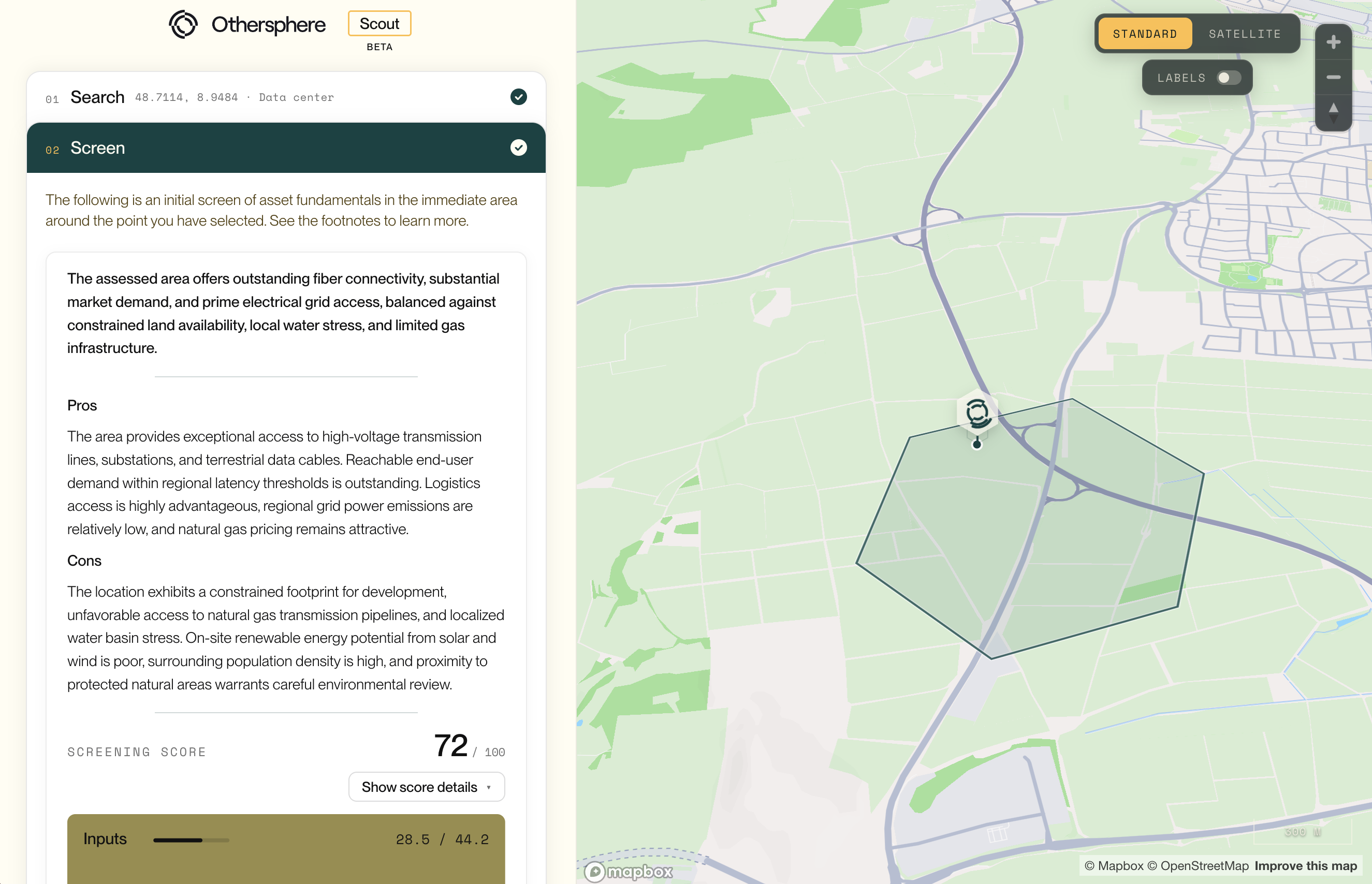
Today we are releasing the beta of Scout, at scout.othersphere.io, a public app to screen infrastructure sites anywhere in the world. Choose an asset type, choose a location, and instantly see an initial screen of its viability.
Othersphere exists to optimize the deployment of high-performance infrastructure worldwide. Our platform indexes more than 60 datasets to over 180 million locations, and models each one from the bottom up.
Until now, that work has mostly reached people through our Explorer software and our full site assessments. Scout opens a narrow view of the same derived data to anyone who wants to look.
Scout has three steps:
The beta launches with two asset types: data centers and utility-scale solar PV.
Scores are for a generalized version of each asset type. Project details, such as the size of a solar facility or the power supply goals of a data center, would shift how factors are weighted.
Weighting is a judgment, not a measurement, and different stakeholders will weigh the same factors differently. A few constraints are severe enough to be deal-breakers, which set the overall score to zero.
Scout shows topic scores and not the underlying values, because much of the data behind them is licensed. The FAQ in the app explains how the score is built.
Scout is deliberately light. It scores dozens of data topics indexed to each ~0.7 km² tile, which is enough to decide where to look harder. A full site assessment is where that harder look happens.
A full assessment adds factors the global screen leaves out entirely, such as community sentiment and permitting, along with detail on labor availability, zoning, and incentive programs. It works at the level of the individual property, confirms and refines the screening data with hyperlocal research, and ends with comprehensive scoring and a go/no-go recommendation.
Assessments typically run 100-150 pages of fully cited analysis and arrive in three days or less. They are available today for data centers and now utility-scale solar PV.
In the months ahead we will keep adding asset types to both Scout and our site assessments. Onshore wind and BESS are next in line based on feedback so far, and we want to hear which assets matter to you.
So please explore the globe and share it as you see fit. Scout is in beta ahead of its formal launch, and your comments will shape what we add.
If you need detailed diligence at a location you choose, request it through the app or reach us at explore@othersphere.io.
How long should it take to learn whether a site deserves a second look? For most infrastructure teams the answer is still weeks. Research is scattered and manual, and the first red flag often appears after real money has been spent. Today we are releasing the beta of Scout, a public app to instantly screen infrastructure sites anywhere in the world.

What decides whether a utility-scale solar project gets built? It is never just the sun, as projects more often stall on grid queues, planning risk, land encumbrances, and local opposition, and those tend to surface after weeks of research and spend.
Today Othersphere site assessments are generally available for utility-scale solar PV. Each one delivers detailed, fully cited diligence on a location you choose, in three days or less.
We released site assessments for data centers earlier this year, and teams have since used them across North America, Europe, Asia, and Oceania. Solar PV is the first expansion of that coverage.
The method is the same. Our platform indexes more than 60 datasets to over 180 million locations. An AI research system then investigates the local detail that global data cannot hold, reviewing thousands of documents, webpages, and videos. Our team reviews the result before delivery.
Assessments typically run 100-150 pages. Each one has four parts:
An optional module adds asset-level financial analysis, using our models or yours.
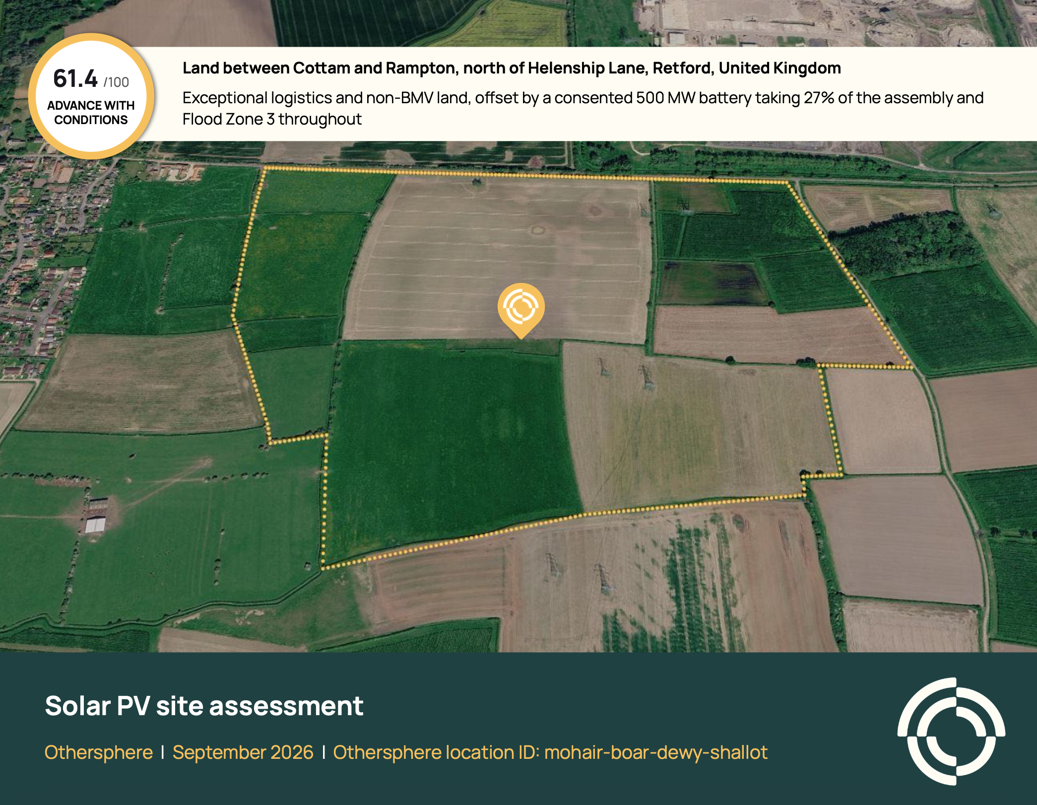
This sample assessment covers roughly 27 MWp of solar on farmland near Retford in the United Kingdom. It scores 61.4 out of 100, with a recommendation to advance with conditions, across 143 pages and 477 cited sources.
The solar resource is viable and the logistics are exceptional. The findings that decide the project sit elsewhere:
The assessment closes with four specific actions to take before committing more capital, from a grid connection application to a topographical survey.
Slow diligence limits pipeline quality, because a team can only look closely at a few sites. With a full assessment in days, developers can vet more locations and drop the weak ones before paying for options, surveys, or consultants.
For operators and financiers, the same report gives a cited view of project fundamentals before capital is committed. Across our assessments, teams reach decisions in 95% less time.
An assessment does not replace surveys, title searches, or professional advice. It tells you which of them to commission first, and which sites do not merit the expense.
The quickest way in is Scout. Select utility-scale solar PV, screen your location, and request a full assessment from within the app. A request is not an order; we follow up to confirm the location and asset configuration first.
You can also reach us directly at explore@othersphere.io.
Onshore wind and BESS are next in line for both Scout and our site assessments. If there is an asset type you need sooner, please tell us.
What decides whether a utility-scale solar project gets built? It is never just the sun, as projects more often stall on grid queues, planning risk, land encumbrances, and local opposition, and those tend to surface after weeks of research and spend. Today Othersphere site assessments are generally available for utility-scale solar PV. Each one delivers detailed, fully cited diligence on a location you choose, in three days or less.
Please reach out if you would like to learn more about Othersphere, our products, and opportunities to partner in accelerating deployment of high performance, sustainable infrastructure.


